Maps

Maps, including plat books, atlases, Sanborn maps and topographic maps.

State of Wisconsin Collection

State of Wisconsin Collection

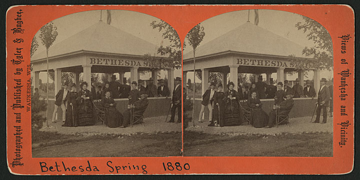
The State of Wisconsin Collection presents writings about the state of Wisconsin and unique or valuable materials that relate to its history and ongoing development. The collection includes published material as well as archival materials such as books, manuscripts, sound recordings, photographs, maps and other resources.

Upper Mississippi River Conservation Committee Collection

The Upper Mississippi River Conservation Survey Committee was established in Dubuque, IA, in 1943, originally comprised of 22 biologists from Iowa and the surrounding states of Illinois, Wisconsin, Minnesota, and Missouri. Since then, the UMRCC dropped “Survey” from their name and has grown to more than 200 resource managers working in multiple disciplines including fisheries, mussels, recreation, wildlife, water quality, vegetation, education, and law enforcement. This collection is a result of a partnership between the UMRCC and Murphy Library to provide both digital and physical access to the UMRCC Library, now housed at Murphy Library.

Walworth County Plat Map 1857

Walworth County Plat Map 1857

The Walworth County Plat Map of 1857 is the oldest and one of the most frequently used maps in the UW-Whitewater Archives. This digitized map allows users to click a township within Walworth County and view the database results for all residents and properties within that township, as documented in 1857.

Waterford Area Local History

Waterford Area Local History

The history of the Waterford area in western Racine County, Wisconsin is documented here in books, manuscripts, high school yearbooks, photographs, maps and newspapers. This digital collection is a collaboration of many Waterford area agencies including Waterford Public Library, the Village of Waterford, Waterford Area Chamber of Commerce, Waterford Union High School and the personal collections of many of the descendants of pioneer families.

Waukesha County History 1870-1920

Waukesha County History 1870-1920

The materials in this digital collection depict the industries, people and structures important to the development of Waukesha County from 1870-1920. Many of the images come from the collection of Warren S. O’Brien (1898-1988), a prolific Waukesha photographer.

Wisconsin Digital Archives

This growing collection of documents about the activities, functions and policies of Wisconsin State Government contains documents published by the Executive and Judicial branches, state government task forces, initiatives, boards, commissions, councils and special study groups. The Wisconsin Digital Archives is a collaborative effort managed by the Wisconsin Department of Public Instruction as part of the Wisconsin Document Depository Program.

Wisconsin in the Civil War

To mark the 150th anniversary of the U.S. Civil War (1861-1865), the Wisconsin Historical Society created this digital collection containing dozens of diaries, regimental histories and book-length memoirs, thousands of soldiers’ letters, hundreds of newspaper articles and more than 1,000 photographs, maps and other images.

Wisconsin Public Land Survey Records

Wisconsin Public Land Survey Records

The field notes and plat maps of the public land survey of Wisconsin are a valuable resource for original land survey information, as well as for understanding Wisconsin’s landscape history. The survey of Wisconsin was conducted between 1832 and 1866 by the federal General Land Office. This work established the township, range and section grid; the pattern upon which land ownership and land use is based.

View All